"...the ornithologists still had serious doubts. Sutton finally put it directly: 'Mr. Spencer, you're sure the bird you're telling us about isn't the big pileated woodpecker?'

"Spencer exploded. 'Man alive! These birds I'm tellin' you all about is kints!' he shouted in their faces. 'Why, the pileated woodpecker's just a little bird about as big as that.' He held his fingers a few inches apart. 'A kint's as big as that!' he said, holding his arms wide... 'Why, man, I've known kints all my life. My pappy showed 'em to me when I was just a kid. I see 'em every fall when I go deer huntin' down aroun' my place on the Tinsaw. They're big birds, I tell you, big and black and white; and they fly through the woods like pintail ducks!'

"After Spencer's outburst, the members of the team were all believers -- not just because of his vehemence, but because his description was so accurate. Ivory-bills do not have the typical bounding flight of the pileated woodpecker. They generally fly away high and straight, with stiff flight feathers, looking very much like a pintail, and their call is a distinctive nasal kent, kent, kent -- very similar to the local name Spencer used, kint. Sutton and the others couldn't wait to get to the bayou and start searching.

"As it turned out, that was not an easy proposition..." --Gallagher, Tim. The Grail Bird: Hot on the Trail of the Ivory-billed Woodpecker, pp. 10-11: "Of People and Peckerwoods."

Wednesday, March 29, 2017

Swamp Watch: 22 March 2017

I have been absent over-long from the Pascagoula Swamp, due largely to obligations to my day job and the demands brought by Spring to small-time gardeners like myself.  I managed to get back afield for half a day, though, and headed down to the Hutson Lake sector of the Pascagoula WMA, an area I call the Stronghold.

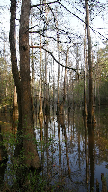
Much of our efforts in the Pascagoula River Basin have been exploration -- surveying remote pockets of bottomland and swamp forest habitat.  I doubt that we will ever visit every corner of the Basin, but as the number of places new to us decreases, the most promising ones become fixed as sites for longer-term survey and surveillance.  The Stronghold is such a place.

Deer were moving near the trailhead in the pre-dawn gloom.  I was far along the old logging trail I call Hollow Man Road at sunrise (around 6:30 A.M., Central Standard Time), bound for the network of sloughs where I'd had an intruiging but inconclusive experience almost a year ago.  Temperatures were in the upper 60's (Fahrenheit), with a nice breeze.  Early cloud cover cleared out by mid-morning.  Bird activity was very high, though I do not think the Spring warblers have yet arrived; and of woodpeckers, I saw or heard all the usual suspects:  downy, red-bellied, red-headed, and pileated woodpeckers, as well as flickers.  I believe the yellow-bellied sapsuckers have left these parts, though, and there was no sign of hairy woodpeckers, which are in any case uncommon to rare in the Basin.

A great egret and a pair of catcalling kingfishers greeted me as I settled into a nook at the base of an oak overlooking a sun-dappled slough.  It was 8 A.M., and I planned on a 2-hour watch.

You can follow some of my progress along Hollow Man Road in the next four videos:


In April of last year I found a sweet gum that appeared to me to exhibit dramatic woodpecker scaling.  I have since concluded, after some correspondence with a forester friend, that lightning likely was the cause, at least initially; though it is possible that some of the scaling was done by woodpeckers, I can not with any degree of certainty attribute it to Ivorybills.  The sweet gum has died.


 Excavation into the still-hard sapwood.

 Large sections of bark are beginning to separate from the sapwood, although the bark still retains much of its strength. 


 Superdominant red oak near the trail. Spruce pine in foreground.

 New and impressive beaver dam.


Observation post for my two-hour watch.

Moon over the Stronghold.

I was treated to a nice show after only a few minutes of sitting very still:  a pair of otters.

They didn't spend much time watching me, and went on about their business.

A barred owl came along not long after the otters disappeared.  He spied me soon enough.


I guess it decided I was up to no good.

A strong breeze created a brief shower of catkins.

Unlike my still hunt there last year, I heard no kent-like calls or Campephilus-style woodpecker knocks, and had no possible visual IBWO encounter.  But on the hike back north I was treated to this:

 The swallow-tailed kites have returned to the skies above the Basin.


As well as a feral hog just off the trail, a blackish individual I believe I may have encountered in the area before.  The wind shifted as I tried to get a photo, though, and it trotted off into the underbrush.

I hope I can get back to the Stronghold soon for another still hunt like this, while the days are still pleasant, and the forest loud with the conversations of birds.


Sunday, March 5, 2017

Breakout North: John Goff Slough, 2 March 2017

I was fortunate enough to be able to get out into the field this past Thursday, after a three-month absence.  My good friend Richard Ezell and I headed back down to the south end of the Pascagoula WMA, where I hoped to do a little more exploring in the area between John Goff Slough and the Pascagoula River.  (I have since discovered that the south end of the Slough may also be referred to as Files Pond on old USGS maps, but I will continue to refer to it as John Goff Slough.)  The remoteness of the area and the excellent habitat continue to intrigue me, and I also hoped to perhaps find a way around the northern tip of the ancient oxbow, and to explore along its old outside shoreline.

The day was clear and cool, and blustery.  The swamp and bottomland forest was noisy throughout our hike with the groan and crack of the great trees as they bent in the wind.  We bore northward from the trailhead, between Lice Lake and the River.  Beyond a long, slender lake (unnamed on Google Earth), the trail ended; but we easily navigated the relatively open bottomland, keeping the River in view to our left.  Broad swathes of sand in the woods hinted at past flooding by the Pascagoula.  Eventually we found a trail again, which turned out to be one I had walked before.  We continued northward, and I was pleased to find that the trail did indeed wander around the northern tip of John Goff Slough.  Richard and I followed it another mile or two before venturing out into the muck of the old lake bed for a closer look at the baldcypresses and tupelos, then turned to follow the trail back.  Our total hike that day was six miles.

The water of John Goff Slough looked very low to me, though the River and nearby lakes seemed full enough.  We found no woodpecker scaling of note, and heard no kents, SK's, or DK's; but we saw and heard Pileated, Downy, and Red-bellied Woodpeckers, along with sapsuckers and flickers.  I continue to be impressed with the quality of the habitat there, though, and I hope to return to continue my survey of the Slough's outside shoreline.

Near the trailhead.

Pascagoula River from the east bank.

Typical view of the bottomland between the River and John Goff Slough.

Richard and a very large water oak at trailside.


The area to the north of us is clear-cut, privately-owned land.

Old woodpecker cavity on a downed baldcypress.

View of the dry swamp forest from the muddy northern edge of John Goff Slough.

Sunday, February 5, 2017

Frank

Today the community of IBWO searchers, researchers, and enthusiasts is sadly diminished with the passing of our friend, Frank Wiley of Louisiana.  Our deepest sympathies are with his family and friends.  Mark Michaels of Project Coyote has posted a tribute in words and photos

Memory eternal, Frank.  Tell Mr. Tanner and Mr. Kuhn we said 'hello.'

Friday, December 9, 2016

The Old Ones of Black Swamp and Big Swamp, 27 November 2016

My brother Brian and I headed back to the Pascagoula River Basin to explore the habitat of south-central Big Swamp.  I was encouraged on my last trip to Big Swamp by the magnificence of the bottomland hardwood and swamp forest I found in the east-central part of the Swamp; and I imagined that the prolonged drought afflicting our area would leave many of the creeks and sloughs veining the Swamp high and dry, affording access where water was normally a barrier.

Dawn came clear and cold -- 28 degrees (Fahrenheit) -- as we turned onto the WMA road to Thieves' Landing on Black Creek.  The road ambles alongside a narrow arm of Black Swamp, which sheathes Black Creek for miles before the creek meets its destiny, the Pascagoula River.  To our delight, we saw that the normally flooded Black Swamp was indeed dry, its bed a rust-colored carpet of baldcypress needles through which the grey cypress knees jutted like innumerable little headstones.  We knew that a grandfather cypress lurked not too off in there; so Brian parked just off the road, we pulled on our boots, and plunged into Black Swamp.

We found the grandfather soon enough, a mighty relict baldcypress, hollow like all the others we have encountered in the Basin.  To our great surprise, we found three others of similar size in close proximity, and the bones of a fourth, in his ruin still holding court in his corner of Black Swamp.  Seldom do we find so many of these Old Ones in such close proximity.  I considered it a good omen.

We later decided that an animal was probably responsible for the debris inside the tree, as the cavity is a bit too small for an adult human to squeeze through.

 The remnant.  Photo:  Brian Carlisle.

 Photo:  Brian Carlisle.

 Photo:  Brian Carlisle.


 Photo:  Brian Carlisle.

 Photo:  Brian Carlisle.


Photo:  Brian Carlisle.


 Woodpecker work, taking advantage of natural cavities.


Photo:  Brian Carlisle.

Photo:  Brian Carlisle.

 There are numerous woodpecker cavities in this hollow one.


I really never get tired of encounters with these giants.  Photo:  Brian Carlisle.

 Photo:  Brian Carlisle.

 Photo:  Brian Carlisle.

Photo:  Brian Carlisle.

Photo:  Brian Carlisle.

Photo:  Brian Carlisle.


 Black Creek, as seen from the high ridge dividing it from Black Swamp.  Photo:  Brian Carlisle.

 Part of Black Swamp, as seen from Thieves' Landing.  Photo:  Brian Carlisle.

 Hauling out the Kuhn.  Photo:  Brian Carlisle.

Black Creek.   Photo:  Brian Carlisle.

 A few minutes later, when we were getting back into Brian's truck, I realized I had left my paddles in my truck, at Brian's house.  So much for the good omen.  We ended up splitting Brian's set up, and managed to scoot across Black Creek using 1 paddle each with little trouble.  Stowing the kayaks on the east bank, we set off on the smallish trail cutting eastward, making for Big Swamp Road, an ATV route that runs north-south and is maintained by the WMA people.  We planned on bearing south along the road, which would take us through country we had not seen before.

Bird life was muted as we walked along at a good clip.  The most active birds seemed to be pileated woodpeckers.  Leaves are still falling here, and Big Swamp was truly noisy with their clatter, as well as the noise of what looks to be a bumper crop of squirrels, making a racket like deer as they zip along the forest floor.  The deer were moving about, but the resident hogs made no appearance for the duration of our time there.  Dogs bayed in the distance.  The great spiders are dead or dying, some still hanging lifeless in their rent and ruined webs, twisting in the breeze.

Though I am familiar with the area, the drought-stricken Swamp caused me some confusion, as creeks and sloughs that normally both give definition and limit movement were nearly unrecognizable in places.  The east-west trail is seldom used, and we were often hard pressed to find it, until we found ourselves wandering a bit aimlessly in the autumn woods, with only the rising Sun to guide us.  Eventually we came upon a trail bordering what looked to be a nearly dry lake.  Bewildered, I remarked that I had never been there; but Brian jogged my memory, and I realized that we had reached German Slough, which is normally impassable much of the year and imposes a non-negotiable wet feet penalty for its crossing.

The morning warmed quickly as we came upon the north-south Big Swamp Road.  Standing there leaning on our walking-staves, we heard the growl of a small engine from the north, and the clang of metal.  Presently a hunter on a four-wheeler approached, pulling a rather rickety homemade kennel on a trailer.  We waved as he turned west towards German Slough, and the clanging faded into the Swamp's natural white noise.  Incredibly, he was the only hunter we'd encountered to that point in our hike -- though it was a Sunday morning, it was still Thanksgiving weekend, a time when the woods of south Mississippi are simply stiff with orange-clad hunters, their trucks, and their dogs.

I saw as we walked south that the WMA personnel had cleared the encroaching vegetation a bit from either side of the road.  Fine old bottomland hardwood forest lay on either side; water oak dominates, with sweet gum somewhat less of a presence than in the Stronghold to the north.  Now and again a dry slough could be seen through the trees, the grey-white trunks of tupelos shining in the morning light.  We passed other trails that branched here and there off Big Swamp Road; some were marked, including the one to Ferrell Dead River, which I had taken earlier in the year, while others were marked with letters that held no meaning for us.  A new sign marked Albritton Road, which led westward, back to Black Creek.  We continued south, though, until a straight east-west clearing bisected the Road.  Signs indicated we were on the boundary line between George and Jackson Counties.  There we turned east, heading for what looked like a very large, swampy area.  It turned out to be a really beautiful, dry swamp forest, with at least one relict baldcypress.

Beyond the swamp lay what seems to be called (at least in this area) an eddy -- a large pond/small lake off the Pascagoula River, its water replenished by overflows from the River.  A boat lay nearby, its hull riddled with bullet-holes.  We pushed beyond the eddy, until the trail ended on a high bluff overlooking the River, the furthest point of our hike that day.

We were overtaken during the return hike by several friendly, radio-collared hunting dogs, one of which shared the road with us a mile or more and napped while we paused to rest,  before taking its leave.  Still some minutes from the intersection with the east-west trail, we met a friendly older couple on a four-wheeler, headed for a favored fishing spot to the southwest.  They informed us of some very big cypress trees on nearby Albritton Road, which they said eventually wound north to join up with the trail across from Thieves' Landing, where we'd left the kayaks.  I was skeptical, as my only hike in that area of Big Swamp in the year prior found the trail vanishing in the trackless bottomland; but we were eager to see more relict cypresses and new territory, and to shave if we might some time off our return hike.

Very soon our detour was rewarded with some hulking, wizened old cypresses near and around a small lake where several boats were moored.  The lake has no name on my maps of the area, so I am calling it Mystics' Lake, after the rather ancient, unearthly presence of the grandfather cypresses along the shoreline.

Unfortunately, not far past the lake and a network of dried-up sloughs, the trail faded and vanished, and we were left to navigate as best we might.  Luckily, after a half hour or so of brisk walking and frequent checking of the GPS, we found ourselves back on the trail, and were back at the boats and crossing Black Creek in short order.  Our total hike was a little less than eight miles.


The south of Big Swamp.  Ferrell Dead River and Lingum Lake are to the north of our location here.

The dry swamp.

German Slough, tamed by the drought.

Nuttall's Oak.

Palmetto graces the bottomland.

South on Big Swamp Road.  Photo:  Brian Carlisle.

Photo:  Brian Carlisle.

Photo:  Brian Carlisle.

We find old boats like this sometimes in odd corners of Big Swamp.  

The eddy as seen on Google Earth.

Impressive swamp nearer the Pascagoula River.


 Photo:  Brian Carlisle.

 Photo:  Brian Carlisle.

 Photo:  Brian Carlisle.

 Photo:  Brian Carlisle.

 Photo:  Brian Carlisle.

Photo:  Brian Carlisle.

We found ourselves, as usual, across from an inviting sandbar on the Pascagoula.


Photo:  Brian Carlisle.

Swamp chestnut oak on the George-Jackson County line.  I have seen many impressive individuals of this species, but this one may be the largest yet.

Photo:  Brian Carlisle.


Photo:  Brian Carlisle.

The bark on this young cypress has been severely shredded.


 Dry slough near Albritton Road, en route to Mystics' Lake.  Photo:  Brian Carlisle.

Photo:  Brian Carlisle.

Photo:  Brian Carlisle.

Another Old One, lording it over his corner of Big Swamp along Albritton Road.

This red maple's roots found ample purchase on a baldcypress stump.  Photo:  Brian Carlisle.

Photo:  Brian Carlisle.

 Mystics' Lake.  Photo:  Brian Carlisle.

Photo:  Brian Carlisle.

Photo:  Brian Carlisle.

Photo:  Brian Carlisle.

Photo:  Brian Carlisle.

Photo:  Brian Carlisle.


We neither saw nor heard evidence of ivorybills, though the habitat is superb.  We did spy a number of large woodpecker cavities, and though none of them struck me as unusual or intriguing, it is difficult (if not impossible, for me) to make substantive determination from cavities alone.  Feeding sign, in the form of Campephilus-style bark scaling, is still (to my mind) a more sure route of detecting Ivorybill activity in an area.  With that in mind, I will likely return in January to the only locale in our search area I feel relatively comfortable bears that kind of sign -- the Stronghold, around and below Hutson Lake, in the north of the Pascagoula River WMA.  Reports for the next 2-3 months will likely be brief, and light on the photography, save for those rare visits to uncharted areas in the Basin.