IBWOH's: Richard Ezell, Brian Carlisle, Chris Carlisle.
Summary: Kayaking Black Creek to Big Swamp, in the Pascagoual Wildlife Management Area.
Big Swamp, in the central Pascagoula WMA, has been mentioned elsewhere as promising potential ivorybill habitat (see Cornell's "Final Report" link at right). I've been itching to get into it for months now; but access is extremely limited, to the best of my knowledge, by a long boundary of private property (mostly hunting and fishing camps) to its north, Black Creek to the west, and (of course) the Pascagoula River itself, forming the swamp's eastern boundary. Regarding private land in this corner of the world, one need only keep one thing in mind: respect it, or get shot. It's that simple. Regarding the Pascagoula River, it may as well be the Amazon -- I have neither the means nor the will to cross it. That left only Black Creek for my scheme to gain entry to Big Swamp... thus my purchase of the Kuhn in January. A float of less than a mile from the Mississippi Highway 57 bridge, and "excellent habitat... second only to Congaree National Park as an area of high quality hardwood habitat for IBWOs" (Cornell's "Final Report," p. 26) would be open to us for exploration.
Big Swamp is, well, big -- around 4-5 miles at its widest, and nearly ten miles in length (including Black Swamp and Red Swamp). Looking at the Google Earth representation, the terrain is formidable: aside from Black Creek, which is almost a river itself as it approaches the Pascagoula River, and Red Creek, joining the Black from the west, there are numerous smaller creeks and streams lacing the area, not to mention numerous large oxbow lakes, ponds, bogs, sloughs. Remnants of old logging roads, some now marked on the WMA map as ATV trails, can be seen on the Google Earth map, in addition to some oddly-placed and oddly-shaped small fields and clearings in the forest. In the north of Big Swamp, just below where the Pascagoula turns eastward at Sandy Wash Bend, there are no less than four decent-sized lakes: Bilbo Dead River, Woodard Dead River, Goff Dead River, Wells Lake. All are nearer to the Pascagoula River than they are to Black Creek. It is, during the mildest of seasons, remote and incredibly challenging habitat -- the perfect place, to my mind, for the ivorybill to make a last stand in Mississippi.
My plan was for Richard, Brian, and I to kayak down Black Creek until we reached WMA (public) land, then to strike out overland for the nearest trail. Ideally, guided by my maps, we would explore the lands below Sandy Wash Bend, and the above named lakes in particular. We all knew that the local rivers and creeks would be up, since it has been raining nearly every day here in south Mississippi for the better part of two weeks -- one of the wettest, muddiest months of March that I remember.
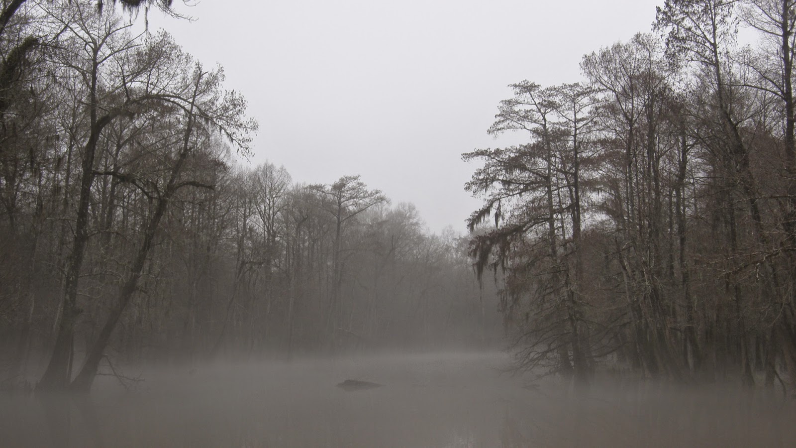
The morning was overcast and only a bit cool (around 60 degrees Fahrenheit), with no rain or wind. We pulled off the highway to the launch a little after dawn, and saw this:


Or so we thought. Our initial mistake was only slowly becoming evident, as we were continually pushed farther northward still, and the deep channels increased in number, thwarting us at nearly every turn. At least once, we realized the classic sign of those lost in the woods: recognizing a rather unique mass of holly roots near deep water, Richard and Brian remarked that we had gone in a circle. It was true. Incredulous, I double-checked my compass for accuracy, as if it might have electronics that could fail. Knowing that we must press westward if we were to reach Black Creek and the kayaks, we braved deeper water, and soon our rubber boots were full as we slogged through the swamp, at times above our knees in the flood. Adding to our anxiety, Richard noted that the waters seemed to be still rising, and that we had not actually dragged our kayaks all that very far off at all from Black Creek's surge.


Summary: Kayaking Black Creek to Big Swamp, in the Pascagoual Wildlife Management Area.
Big Swamp, in the central Pascagoula WMA, has been mentioned elsewhere as promising potential ivorybill habitat (see Cornell's "Final Report" link at right). I've been itching to get into it for months now; but access is extremely limited, to the best of my knowledge, by a long boundary of private property (mostly hunting and fishing camps) to its north, Black Creek to the west, and (of course) the Pascagoula River itself, forming the swamp's eastern boundary. Regarding private land in this corner of the world, one need only keep one thing in mind: respect it, or get shot. It's that simple. Regarding the Pascagoula River, it may as well be the Amazon -- I have neither the means nor the will to cross it. That left only Black Creek for my scheme to gain entry to Big Swamp... thus my purchase of the Kuhn in January. A float of less than a mile from the Mississippi Highway 57 bridge, and "excellent habitat... second only to Congaree National Park as an area of high quality hardwood habitat for IBWOs" (Cornell's "Final Report," p. 26) would be open to us for exploration.
Big Swamp is, well, big -- around 4-5 miles at its widest, and nearly ten miles in length (including Black Swamp and Red Swamp). Looking at the Google Earth representation, the terrain is formidable: aside from Black Creek, which is almost a river itself as it approaches the Pascagoula River, and Red Creek, joining the Black from the west, there are numerous smaller creeks and streams lacing the area, not to mention numerous large oxbow lakes, ponds, bogs, sloughs. Remnants of old logging roads, some now marked on the WMA map as ATV trails, can be seen on the Google Earth map, in addition to some oddly-placed and oddly-shaped small fields and clearings in the forest. In the north of Big Swamp, just below where the Pascagoula turns eastward at Sandy Wash Bend, there are no less than four decent-sized lakes: Bilbo Dead River, Woodard Dead River, Goff Dead River, Wells Lake. All are nearer to the Pascagoula River than they are to Black Creek. It is, during the mildest of seasons, remote and incredibly challenging habitat -- the perfect place, to my mind, for the ivorybill to make a last stand in Mississippi.
My plan was for Richard, Brian, and I to kayak down Black Creek until we reached WMA (public) land, then to strike out overland for the nearest trail. Ideally, guided by my maps, we would explore the lands below Sandy Wash Bend, and the above named lakes in particular. We all knew that the local rivers and creeks would be up, since it has been raining nearly every day here in south Mississippi for the better part of two weeks -- one of the wettest, muddiest months of March that I remember.
The morning was overcast and only a bit cool (around 60 degrees Fahrenheit), with no rain or wind. We pulled off the highway to the launch a little after dawn, and saw this:
Black Creek's bank is normally out near where the line of trees to the left stops above and to the left of image center.
No one else was there. Before loading my gear, I took the Kuhn out into Black Creek's main current straightaway, as a test. I did not find it unmanageable. I returned to the launch, and we three set off in short order downstream, towards the WMA.
The trip downstream was relatively easy, even for me. (My only previous kayaking experience was, as I have recounted in a previous post, on the lake behind my brother Brian's house.) We quickly passed the fishing camps along the bank to our left, and an aluminum boat which can actually be seen from Google Earth. Then, grove after magnificent grove of river birch, a houseboat on our right, and the river bent.
Eddys and swirls and the surge of Black Creek's main channel made the going challenging at times. Brian and I were in our ten-foot fishing kayaks. Richard owns a magnificent 14-foot canoe, but opted for an 8-foot kayak instead, anticipating the narrower confines of the swamp. His strength and experience served him well. Brian usually ranged fifty yards or so ahead in his sand-colored Voyager, scouting the way. I kept up fairly well, surprising myself, though my inexperience sent the Kuhn into an occasional 360-degree spin, or nosing into waterlogged brush.
Bird life was muted. Once, a wild turkey lifted off a few yards from the left bank, the heavy whoosh of its wingbeats fading as it retreated deeper into the swamp fastness. A hawk, possibly a broad-winged, floated up from the south, then out over the private land beyond the right bank. Black Creek overflowed its banks in many places, and I feared after a while that we would not be able to locate a suitable landing. I do not recall how long we alternately floated and paddled, until we passed the marker denoting WMA land, and found a place to beach the boats, near what had been a creek mouth in drier months. Now Black Creek bled its waters out into the stream, which flowed away in the opposite direction, into the bottomland. We clambered out of our respective crafts and pulled them a few yards from Black Creek, eager to at last begin our survey of Big Swamp. This we did, setting out east-southeastwards towards a long, narrow field on my map, not knowing we had already made a mistake.
A couple of hundred yards in, and we were met with flooded bottomland. It was difficult to tell which direction the water flowed -- away from Black Creek, or towards it. The floodwaters were shin-deep in most places, but here and there our path forward was barred by deep channels that forced us, despite our best efforts, gradually farther and farther north. We pressed on, crossing a wide swathe of flooded forest, until we began to hear the noise of automobiles. I realized that we had gone much too far to the north, and were pressing near to private land, where our way would also (according to the map) eventually be blocked by a wide, shapeless slough. Determined, I kept out my compass, and Richard and Brian their phones with their GPS systems, and we pressed onward. Still, the deep channels seemingly pushed us northward, and even westward, back towards Black Creek.
(Photo: Brian Carlisle)
(Photo: Brian Carlisle)
(Photo: Brian Carlisle)
Tree stand. (Photo: Brian Carlisle)
I don't remember how long we continued on like that, but at length it was decided that Big Swamp was impassable, and that we should return to the kayaks and make our way back to the bridge. With a bit of a heavy heart, I turned my compass to the south-southwest, and we began to make our way back to Black Creek.
Or so we thought. Our initial mistake was only slowly becoming evident, as we were continually pushed farther northward still, and the deep channels increased in number, thwarting us at nearly every turn. At least once, we realized the classic sign of those lost in the woods: recognizing a rather unique mass of holly roots near deep water, Richard and Brian remarked that we had gone in a circle. It was true. Incredulous, I double-checked my compass for accuracy, as if it might have electronics that could fail. Knowing that we must press westward if we were to reach Black Creek and the kayaks, we braved deeper water, and soon our rubber boots were full as we slogged through the swamp, at times above our knees in the flood. Adding to our anxiety, Richard noted that the waters seemed to be still rising, and that we had not actually dragged our kayaks all that very far off at all from Black Creek's surge.
Later, somewhat before we came back out to Black Creek, Richard guessed what had happened: we had beached the kayaks on an island made by the rising waters of the swamp. Eventually, we were forced into a couple of anxious channel crossings, one utilizing a dead (and mostly rotten) beech tree, and later by way of a somewhat smaller, live holly tree that leaned out several feet above a rushing stream.
(Photo: Brian Carlisle)
(Photo: Brian Carlisle)
I look for signs of scaling, trying unsuccessfully to take my mind off our plight. (Photo: Brian Carlisle)
Finally, Brian glimpsed a sand bar through the trees, and Black Creek lay before us again. But there was no sign of the kayaks. We explored a bit to the north, but had not gone far before encountering a ruined line of field fence, and a WMA boundary marker. We had come out too far north. Turning back southward, it was another half-hour or more through at times thick undergrowth until we glimpsed the red of Richard's kayak, which along with mine and Brian's had not floated off in our absence. After a rather long break, we shoved off, and began paddling northward, against the current.
Now, we all knew beforehand that we were going to have to paddle back against the current. We all three knew that. But in a few minutes, the reality of inching forward against the surge of Black Creek began to set in. Again, Brian ranged ahead, and eventually called out to us from a tiny landing on the west bank. Reluctantly (I imagined I was doing well) I followed Richard in. Thanks to his GPS, Brian had found a private road that ran alongside Black Creek for nearly half the distance between us and the bridge. It was decided that we would portage our kayaks along the road, until the road bent sharply away from the creek, and we would put in again and paddle the remaining few hundred yards to the bridge.
The road, it turned out, was also flooded in parts:
We alternately dragged/floated our kayaks until, as Brian's GPS had shown, the road turned away from the creek. Now we had no choice: we must battle our way up Black Creek, however long it may take.
So, to make a long and exhausting story short, we did.
Rounding the bend to the boat launch. (Photo: Brian Carlisle)
(Photo: Brian Carlisle)
(Photo: Brian Carlisle)
(Photo: Brian Carlisle)
(Photo: Brian Carlisle)
Conclusions: The forest -- what little of it we managed to survey, that is -- is, in my amateur opinion, excellent habitat, with many large sweet gum, spruce pine, swamp chestnut oak, water oak, and water tupelo. American holly graces much of this forest's understory. Baldcypress is common, though not as prevalent as in other parts of the WMA further north, though there were some nice stands visible beyond our access. As I said before, I was deeply impressed by the lovely stands of river birch, fast becoming one of my favorite trees. All three of us were on the lookout for signs of scaling, but saw none, and heard no kents or double-knocks -- although, admittedly, we were not paying too much attention during a good bit of the survey. We heard red-bellied, red-headed, and downy woodpeckers; we heard a turkey calling; and Richard and Brian heard an owl.
Brian did manage, as he usually does, to find great beauty in the details:
(Photo: Brian Carlisle)
Richard pointed out this snail grazing on fungi. (Photo: Brian Carlisle)
(Photo: Brian Carlisle)
I noticed a living baldcypress with unusual bark peeling, which I have observed in baldcypress elsewhere. I have not yet found out the cause.
Big Swamp won this round. I must admit that I am eager to return... when the waters have receded somewhat, perhaps. And yet, lost days afield this time of year are irreplaceable to those in search of the ivorybill. This is the conundrum faced by searchers in the swamps and bottomlands: how effectively can one survey a vast habitat, when constantly challenged by the habitat itself?