
My brother Brian and I headed back to the Pascagoula River Basin to explore the habitat of south-central Big Swamp. I was encouraged on my last trip to Big Swamp by the magnificence of the bottomland hardwood and swamp forest I found in the east-central part of the Swamp; and I imagined that the prolonged drought afflicting our area would leave many of the creeks and sloughs veining the Swamp high and dry, affording access where water was normally a barrier.
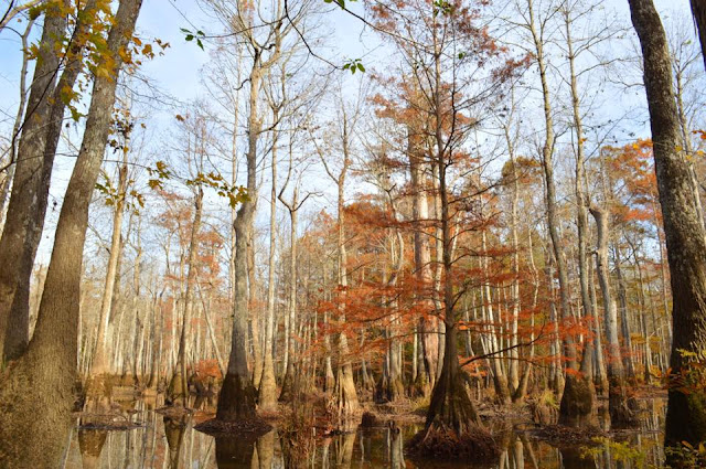
Dawn came clear and cold -- 28 degrees (Fahrenheit) -- as we turned onto the WMA road to Thieves' Landing on Black Creek. The road ambles alongside a narrow arm of Black Swamp, which sheathes Black Creek for miles before the creek meets its destiny, the Pascagoula River. To our delight, we saw that the normally flooded Black Swamp was indeed dry, its bed a rust-colored carpet of baldcypress needles through which the grey cypress knees jutted like innumerable little headstones. We knew that a grandfather cypress lurked not too off in there; so Brian parked just off the road, we pulled on our boots, and plunged into Black Swamp.
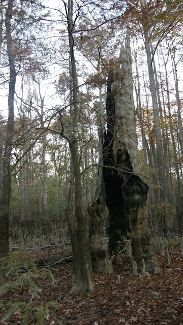
We found the grandfather soon enough, a mighty relict baldcypress, hollow like all the others we have encountered in the Basin. To our great surprise, we found three others of similar size in close proximity, and the bones of a fourth, in his ruin still holding court in his corner of Black Swamp. Seldom do we find so many of these Old Ones in such close proximity. I considered it a good omen.


Bird life was muted as we walked along at a good clip. The most active birds seemed to be pileated woodpeckers. Leaves are still falling here, and Big Swamp was truly noisy with their clatter, as well as the noise of what looks to be a bumper crop of squirrels, making a racket like deer as they zip along the forest floor. The deer were moving about, but the resident hogs made no appearance for the duration of our time there. Dogs bayed in the distance. The great spiders are dead or dying, some still hanging lifeless in their rent and ruined webs, twisting in the breeze.
Though I am familiar with the area, the drought-stricken Swamp caused me some confusion, as creeks and sloughs that normally both give definition and limit movement were nearly unrecognizable in places. The east-west trail is seldom used, and we were often hard pressed to find it, until we found ourselves wandering a bit aimlessly in the autumn woods, with only the rising Sun to guide us. Eventually we came upon a trail bordering what looked to be a nearly dry lake. Bewildered, I remarked that I had never been there; but Brian jogged my memory, and I realized that we had reached German Slough, which is normally impassable much of the year and imposes a non-negotiable wet feet penalty for its crossing.
The morning warmed quickly as we came upon the north-south Big Swamp Road. Standing there leaning on our walking-staves, we heard the growl of a small engine from the north, and the clang of metal. Presently a hunter on a four-wheeler approached, pulling a rather rickety homemade kennel on a trailer. We waved as he turned west towards German Slough, and the clanging faded into the Swamp's natural white noise. Incredibly, he was the only hunter we'd encountered to that point in our hike -- though it was a Sunday morning, it was still Thanksgiving weekend, a time when the woods of south Mississippi are simply stiff with orange-clad hunters, their trucks, and their dogs.
I saw as we walked south that the WMA personnel had cleared the encroaching vegetation a bit from either side of the road. Fine old bottomland hardwood forest lay on either side; water oak dominates, with sweet gum somewhat less of a presence than in the Stronghold to the north. Now and again a dry slough could be seen through the trees, the grey-white trunks of tupelos shining in the morning light. We passed other trails that branched here and there off Big Swamp Road; some were marked, including the one to Ferrell Dead River, which I had taken earlier in the year, while others were marked with letters that held no meaning for us. A new sign marked Albritton Road, which led westward, back to Black Creek. We continued south, though, until a straight east-west clearing bisected the Road. Signs indicated we were on the boundary line between George and Jackson Counties. There we turned east, heading for what looked like a very large, swampy area. It turned out to be a really beautiful, dry swamp forest, with at least one relict baldcypress.
Beyond the swamp lay what seems to be called (at least in this area) an eddy -- a large pond/small lake off the Pascagoula River, its water replenished by overflows from the River. A boat lay nearby, its hull riddled with bullet-holes. We pushed beyond the eddy, until the trail ended on a high bluff overlooking the River, the furthest point of our hike that day.
We were overtaken during the return hike by several friendly, radio-collared hunting dogs, one of which shared the road with us a mile or more and napped while we paused to rest, before taking its leave. Still some minutes from the intersection with the east-west trail, we met a friendly older couple on a four-wheeler, headed for a favored fishing spot to the southwest. They informed us of some very big cypress trees on nearby Albritton Road, which they said eventually wound north to join up with the trail across from Thieves' Landing, where we'd left the kayaks. I was skeptical, as my only hike in that area of Big Swamp in the year prior found the trail vanishing in the trackless bottomland; but we were eager to see more relict cypresses and new territory, and to shave if we might some time off our return hike.
Very soon our detour was rewarded with some hulking, wizened old cypresses near and around a small lake where several boats were moored. The lake has no name on my maps of the area, so I am calling it Mystics' Lake, after the rather ancient, unearthly presence of the grandfather cypresses along the shoreline.
Unfortunately, not far past the lake and a network of dried-up sloughs, the trail faded and vanished, and we were left to navigate as best we might. Luckily, after a half hour or so of brisk walking and frequent checking of the GPS, we found ourselves back on the trail, and were back at the boats and crossing Black Creek in short order. Our total hike was a little less than eight miles.


We neither saw nor heard evidence of ivorybills, though the habitat is superb. We did spy a number of large woodpecker cavities, and though none of them struck me as unusual or intriguing, it is difficult (if not impossible, for me) to make substantive determination from cavities alone. Feeding sign, in the form of Campephilus-style bark scaling, is still (to my mind) a more sure route of detecting Ivorybill activity in an area. With that in mind, I will likely return in January to the only locale in our search area I feel relatively comfortable bears that kind of sign -- the Stronghold, around and below Hutson Lake, in the north of the Pascagoula River WMA. Reports for the next 2-3 months will likely be brief, and light on the photography, save for those rare visits to uncharted areas in the Basin.

Dawn came clear and cold -- 28 degrees (Fahrenheit) -- as we turned onto the WMA road to Thieves' Landing on Black Creek. The road ambles alongside a narrow arm of Black Swamp, which sheathes Black Creek for miles before the creek meets its destiny, the Pascagoula River. To our delight, we saw that the normally flooded Black Swamp was indeed dry, its bed a rust-colored carpet of baldcypress needles through which the grey cypress knees jutted like innumerable little headstones. We knew that a grandfather cypress lurked not too off in there; so Brian parked just off the road, we pulled on our boots, and plunged into Black Swamp.
We found the grandfather soon enough, a mighty relict baldcypress, hollow like all the others we have encountered in the Basin. To our great surprise, we found three others of similar size in close proximity, and the bones of a fourth, in his ruin still holding court in his corner of Black Swamp. Seldom do we find so many of these Old Ones in such close proximity. I considered it a good omen.
We later decided that an animal was probably responsible for the debris inside the tree, as the cavity is a bit too small for an adult human to squeeze through.

The remnant. Photo: Brian Carlisle.

Photo: Brian Carlisle.

Photo: Brian Carlisle.


Photo: Brian Carlisle.

Photo: Brian Carlisle.


Photo: Brian Carlisle.


Woodpecker work, taking advantage of natural cavities.


Photo: Brian Carlisle.

Photo: Brian Carlisle.

There are numerous woodpecker cavities in this hollow one.


I really never get tired of encounters with these giants. Photo: Brian Carlisle.

Photo: Brian Carlisle.

Photo: Brian Carlisle.

Photo: Brian Carlisle.

Photo: Brian Carlisle.

Photo: Brian Carlisle.

Black Creek, as seen from the high ridge dividing it from Black Swamp. Photo: Brian Carlisle.

Part of Black Swamp, as seen from Thieves' Landing. Photo: Brian Carlisle.

Hauling out the Kuhn. Photo: Brian Carlisle.

Black Creek. Photo: Brian Carlisle.
A few minutes later, when we were getting back into Brian's truck, I realized I had left my paddles in my truck, at Brian's house. So much for the good omen. We ended up splitting Brian's set up, and managed to scoot across Black Creek using 1 paddle each with little trouble. Stowing the kayaks on the east bank, we set off on the smallish trail cutting eastward, making for Big Swamp Road, an ATV route that runs north-south and is maintained by the WMA people. We planned on bearing south along the road, which would take us through country we had not seen before.Bird life was muted as we walked along at a good clip. The most active birds seemed to be pileated woodpeckers. Leaves are still falling here, and Big Swamp was truly noisy with their clatter, as well as the noise of what looks to be a bumper crop of squirrels, making a racket like deer as they zip along the forest floor. The deer were moving about, but the resident hogs made no appearance for the duration of our time there. Dogs bayed in the distance. The great spiders are dead or dying, some still hanging lifeless in their rent and ruined webs, twisting in the breeze.
Though I am familiar with the area, the drought-stricken Swamp caused me some confusion, as creeks and sloughs that normally both give definition and limit movement were nearly unrecognizable in places. The east-west trail is seldom used, and we were often hard pressed to find it, until we found ourselves wandering a bit aimlessly in the autumn woods, with only the rising Sun to guide us. Eventually we came upon a trail bordering what looked to be a nearly dry lake. Bewildered, I remarked that I had never been there; but Brian jogged my memory, and I realized that we had reached German Slough, which is normally impassable much of the year and imposes a non-negotiable wet feet penalty for its crossing.
The morning warmed quickly as we came upon the north-south Big Swamp Road. Standing there leaning on our walking-staves, we heard the growl of a small engine from the north, and the clang of metal. Presently a hunter on a four-wheeler approached, pulling a rather rickety homemade kennel on a trailer. We waved as he turned west towards German Slough, and the clanging faded into the Swamp's natural white noise. Incredibly, he was the only hunter we'd encountered to that point in our hike -- though it was a Sunday morning, it was still Thanksgiving weekend, a time when the woods of south Mississippi are simply stiff with orange-clad hunters, their trucks, and their dogs.
I saw as we walked south that the WMA personnel had cleared the encroaching vegetation a bit from either side of the road. Fine old bottomland hardwood forest lay on either side; water oak dominates, with sweet gum somewhat less of a presence than in the Stronghold to the north. Now and again a dry slough could be seen through the trees, the grey-white trunks of tupelos shining in the morning light. We passed other trails that branched here and there off Big Swamp Road; some were marked, including the one to Ferrell Dead River, which I had taken earlier in the year, while others were marked with letters that held no meaning for us. A new sign marked Albritton Road, which led westward, back to Black Creek. We continued south, though, until a straight east-west clearing bisected the Road. Signs indicated we were on the boundary line between George and Jackson Counties. There we turned east, heading for what looked like a very large, swampy area. It turned out to be a really beautiful, dry swamp forest, with at least one relict baldcypress.
Beyond the swamp lay what seems to be called (at least in this area) an eddy -- a large pond/small lake off the Pascagoula River, its water replenished by overflows from the River. A boat lay nearby, its hull riddled with bullet-holes. We pushed beyond the eddy, until the trail ended on a high bluff overlooking the River, the furthest point of our hike that day.
We were overtaken during the return hike by several friendly, radio-collared hunting dogs, one of which shared the road with us a mile or more and napped while we paused to rest, before taking its leave. Still some minutes from the intersection with the east-west trail, we met a friendly older couple on a four-wheeler, headed for a favored fishing spot to the southwest. They informed us of some very big cypress trees on nearby Albritton Road, which they said eventually wound north to join up with the trail across from Thieves' Landing, where we'd left the kayaks. I was skeptical, as my only hike in that area of Big Swamp in the year prior found the trail vanishing in the trackless bottomland; but we were eager to see more relict cypresses and new territory, and to shave if we might some time off our return hike.
Very soon our detour was rewarded with some hulking, wizened old cypresses near and around a small lake where several boats were moored. The lake has no name on my maps of the area, so I am calling it Mystics' Lake, after the rather ancient, unearthly presence of the grandfather cypresses along the shoreline.
Unfortunately, not far past the lake and a network of dried-up sloughs, the trail faded and vanished, and we were left to navigate as best we might. Luckily, after a half hour or so of brisk walking and frequent checking of the GPS, we found ourselves back on the trail, and were back at the boats and crossing Black Creek in short order. Our total hike was a little less than eight miles.

The south of Big Swamp. Ferrell Dead River and Lingum Lake are to the north of our location here.

The dry swamp.

German Slough, tamed by the drought.

Nuttall's Oak.

Palmetto graces the bottomland.

South on Big Swamp Road. Photo: Brian Carlisle.

Photo: Brian Carlisle.

Photo: Brian Carlisle.

We find old boats like this sometimes in odd corners of Big Swamp.
 The eddy as seen on Google Earth.


Impressive swamp nearer the Pascagoula River.


Photo: Brian Carlisle.

Photo: Brian Carlisle.

Photo: Brian Carlisle.

Photo: Brian Carlisle.

Photo: Brian Carlisle.

Photo: Brian Carlisle.

We found ourselves, as usual, across from an inviting sandbar on the Pascagoula.


Photo: Brian Carlisle.

Swamp chestnut oak on the George-Jackson County line. I have seen many impressive individuals of this species, but this one may be the largest yet.

Photo: Brian Carlisle.


Photo: Brian Carlisle.

The bark on this young cypress has been severely shredded.


Dry slough near Albritton Road, en route to Mystics' Lake. Photo: Brian Carlisle.

Photo: Brian Carlisle.

Photo: Brian Carlisle.

Another Old One, lording it over his corner of Big Swamp along Albritton Road.

This red maple's roots found ample purchase on a baldcypress stump. Photo: Brian Carlisle.

Photo: Brian Carlisle.

Mystics' Lake. Photo: Brian Carlisle.

Photo: Brian Carlisle.

Photo: Brian Carlisle.

Photo: Brian Carlisle.

Photo: Brian Carlisle.

Photo: Brian Carlisle.


We neither saw nor heard evidence of ivorybills, though the habitat is superb. We did spy a number of large woodpecker cavities, and though none of them struck me as unusual or intriguing, it is difficult (if not impossible, for me) to make substantive determination from cavities alone. Feeding sign, in the form of Campephilus-style bark scaling, is still (to my mind) a more sure route of detecting Ivorybill activity in an area. With that in mind, I will likely return in January to the only locale in our search area I feel relatively comfortable bears that kind of sign -- the Stronghold, around and below Hutson Lake, in the north of the Pascagoula River WMA. Reports for the next 2-3 months will likely be brief, and light on the photography, save for those rare visits to uncharted areas in the Basin.
