"...the ornithologists still had serious doubts. Sutton finally put it directly: 'Mr. Spencer, you're sure the bird you're telling us about isn't the big pileated woodpecker?'

"Spencer exploded. 'Man alive! These birds I'm tellin' you all about is kints!' he shouted in their faces. 'Why, the pileated woodpecker's just a little bird about as big as that.' He held his fingers a few inches apart. 'A kint's as big as that!' he said, holding his arms wide... 'Why, man, I've known kints all my life. My pappy showed 'em to me when I was just a kid. I see 'em every fall when I go deer huntin' down aroun' my place on the Tinsaw. They're big birds, I tell you, big and black and white; and they fly through the woods like pintail ducks!'

"After Spencer's outburst, the members of the team were all believers -- not just because of his vehemence, but because his description was so accurate. Ivory-bills do not have the typical bounding flight of the pileated woodpecker. They generally fly away high and straight, with stiff flight feathers, looking very much like a pintail, and their call is a distinctive nasal kent, kent, kent -- very similar to the local name Spencer used, kint. Sutton and the others couldn't wait to get to the bayou and start searching.

"As it turned out, that was not an easy proposition..." --Gallagher, Tim. The Grail Bird: Hot on the Trail of the Ivory-billed Woodpecker, pp. 10-11: "Of People and Peckerwoods."

Wednesday, September 3, 2014

Close Survey: Where the Whang-Doodle Mourneth for His First-Born: The Lands East of Hutson Lake, 3 September 2014

IBWOH:  Christopher Carlisle.

Summary:  Hoping for a drier, less aquatic experience, I hiked the extensive logging roads to the east of Hutson Lake, in the Pascagoula WMA.  The hike took me on a nearly constant southward trajectory, ending at the lake with the giant hollow cypress, who I have named Hollow Man; beyond lies another small muddy lake, which I was unwilling to hike to.  The dawn came late, with clouds from the night's rains lingering until after 7 a.m.   Still, though it was humid, the hike was pleasant enough.  I moved slowly, stopping every 15-20 yards or so to listen, and carefully scanning the trees for cavities and signs of scaling.  This is my method, the Close Survey, similar to the method I used to employ in my squirrel hunts, and which also seems to have been (with some variation) the method of ivorybill searchers in the past.  

A dominant tree species in this area is the water oak, which I do not believe is generally favored by the Ivorybill; but equally abundant are large sweet gums, which I do believe are a favored species.  Swamp chestnut oak is common here, as is red oak, with white oak slightly less so; there are occasional groves of laurel oak and willow oak, and there are at least two old live oaks easily spotted from the trail, one with some scaling evident on a high bough.  Spruce pine is common, with no other species of pine evident.  Strangely, I found no magnolia or sweetbay.  I also encountered no tulip poplar.  Baldcypress is, of course, present in great numbers, along with water tupelo.  Beech (some impressive specimens) and river birch lurk in odd corners near lakes and sloughs.

Pileated and red-bellied woodpeckers were up early, but I did not hear the redheads until somehwhat later. I spied many birds, including yellow-billed cuckoos, a Kentucky warbler, Carolina wrens, and summer tanagers; but they did not seem as active as they used.  Autumn approaches.

 Slough, not far from the trailhead.  It is probably the same winding slough that defeated Richard and I, and claimed my old cell phone.


 Scaling near the trail.


 I revisited the scaling Brian and I had discovered before.


 Golden silk orb-weaver Nephila clavipes, or banana spider.

 Exposed scaling on sweet gum at trailside.  I could find no evidence of another tree having fallen and sloughing the bark off.

 Swamp chestnut oak, showing possible sign of blight.

 Many swamp chestnut oaks in the area were similarly affected.

 Lower bole scaling of this type seems to occur mainly on sweet gum.  On spruce pine, the scaling seldom goes all the way around the tree.


 Note the "clipped" look of the vines.  This leads me to suspect it to be the work of a beaver despite the distance (200-300 yards) from any water source.


Scaling to a young white oak.


Rootings of hog.

Fresh wallow of hog.

South end of north-bound hog. 

Scaling to live oak bough.  Unfortunately, the low light of early morning prevented me from getting a better picture. 

 Cardinal flower.  One of my favorites. 


 Old scaling, 20-30 feet up a sweet gum.


 Romalea guttata, or Eastern lubber grasshopper.  Black adult color phase.  Very common in this area.

 My momma calls 'em "Devil horses."

 Nice cavity in a live water oak.


 A female Prothonotary Warbler, checking me out.

 More scaling.  I could not identify the tree species.

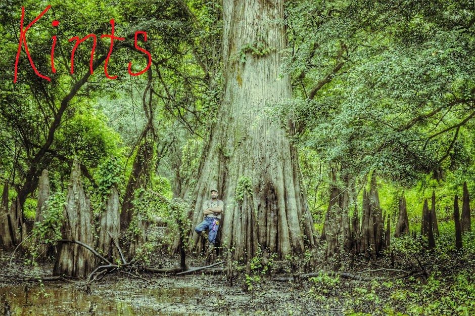
 Hollow Man (left).  I did not disturb his repose this day.


 Furthest extent of the day's hike for me.  I would not wade this slough for a better look at the lake beyond.

 Hog butt imprint.

About halfway back on the return hike, I began to hear the high, forlorn yowls of some lonely creature from the direction of the River, and which followed me for some two hundred yards through the bottomland.  It may have been a bobcat, or a coyote, or a fox; but I thought of my old Professor of Mississippi History at the University of Southern Mississippi, the redoubtable John Edmond Gonzales, the biographer of Senator Lucius Quintus Cincinnatus Lamar.  One day, during our survey of the history of the Great State of Mississippi, Doctor Gonzales held forth regarding Religion in our fair state; and he offered up this gem of oratory, taken from The Harp of a Thousand Strings; or, Laughter for a Lifetime, ed. S.P. Avery, and supposedly gleaned by the latter from a collection of travelling preachers' tales, or parodies thereof:

"Bretheren and sisteren, I do not come before you this evening to engage in any grammar talk or college high-falutin' but I come to prepare a pervarse generation for the day of wrath, and my text, when you find it, you'll find it 'twixt the lids of this old Bible, from the first chapter of Second Chronicles to the last chapter of Timothy-Titus, and when you find it, you'll find it in these words, 'And they shall gnaw a file, and flee into the mountains of Hespudam, where the lion roareth, and the whang-doodle mourneth for its first-born,' ahhh." [Here the preacher breathes out a deep 'ahhh,' for added effect, supposedly.]
     "Now, my bretheren and sisteren, there's different kinds of files.  There's the rat-tailed file, and there's the handsaw file, and there's the crosscut file, and there's the profile and the defile... but the text says, 'they shall gnaw a file, and flee into the mountains of Hespudam, where the lion roareth, and the whang-doodle mourneth for its first-born,' ahh.
     "And brethren and sisteren, there are many kinds of dams.  There's Amsterdam, and then there's Rotterdam, and there's Beaverdam, but the last of all and the worst of all, my bretheren, is "I don't give a damn," but the text says that 'They shall gnaw a file, and flee into the mountains of Hespudam, where the lion roareth and the whang-doodle mourneth for its first-born,' ahh.
     "Now, my bretheren and sisteren, this reminds me of the man who lived upon the north fork of Little Pine Creek in Madison County, North Carolina.  He had a little mill, but he ground a heap of corn, but one night the fountain of the great deep was broken up, and the windows of heaven were opened and the rains descended, the winds came and washed that little man's mill to Kingdom Come.  He got up the next morning and told the good old wife of his bosom that he wasn't worth a damn!  But the text says that 'they shall gnaw a file, and flee into the mountains of Hespudam, where the lion roareth, and the whang-doodle mourneth for its first-born,' ahh.
     "My bretheren and sisteren, this doesn't mean the howling wilderness where John the Hardshelled Baptist fed on locusts and wild asses, but it means the City of New Orleans, the mother of harlots and hard-lots, where corn is six bits a bushel one day and nary a red the next, and where thieves and pickpockets go skitting about like weasels in a barnyard, and where honest men are scarcer n'hen's teeth, and where a woman once took up your beloved preacher and bamboozled him out of a hundred and twenty-seven plunks in three jerks of the eye and the twinkling of a sheep's tail, but she can't do it again, hallelujah!"

Strange, how old threads of memory waft up out of their dustbin at odd whiles.  So, with the Singing River and the yowls of the whang-doodle behind me, and thoughts of John Edmond Gonzales and my days as an academic in my mind, I left the swamp again, to search for the Ivorybill another day. 

 Juvenile Little Blue Heron.

 IBWO-1, always a welcome sight after a hot day on the trail.

 Juvenile white ibis.

Conclusions:  This will be the last survey I will make of the Hutson Lake area of the Pascagoula WMA until leaf-fall later in Autumn.  Hopefully, more bark scaling and cavities will be visible then.  My next IBWO survey area:  Black Creek, for which there is an IBWO encounter (kents) on record from the 1970's.

 Black Creek landing, between Benndale and Wiggins.

 Looking downstream, where after many miles Black Creek eventually joins Red Creek before emptying into the Pascagoula River.

Sunday, August 31, 2014

UPDATE to the Disastrous Day of the Spiders

The Olympus lives!  Sprung to life after sitting in a rice-filled container for two days.  A few of my photos from that ill-fated day:


This young possum was the only mammal we encountered that day.

I hope to return soon, for a less aquatic experience. 

Wednesday, August 27, 2014

Expedition: The Disastrous Day of the Spiders, 27 August 2014

IBWOH's:  Richard Ezell, Christopher Carlisle.

Summary:  An initial visit for photos with the Ancient of Days, followed by a circuitous hiking survey of the spider-infested lands immediately around Hutson Lake, soon became one of the most challenging days in the field this year.

As noted in a prior post, Brian Carlisle and I had discovered the Ancient near an old logging road that eventually led us quickly out of the forest and back to the main road into the WMA.  We had come upon the road as we made our way out of the pathless woods along the Pascagoula River.  At the time, we were only concerned with getting back to our vehicle, but upon later reflection I became curious where the old logging road might lead, thinking perhaps it snaked around the southern end of Hutson Lake to meet with one of the other roads we had hiked that day.  So, leaving the Ancient to his dawn ruminations, Richard and I continued south down the logging road, which is presently (along with the surrounding bottomland) laced with the thick, strong filaments of innumerable banana spider webs.  Soon enough we spotted an end of Hutson, which forms a reverse-C, its ends pointing directly west, towards the River.  As for the Road, it withered and faded into nothing; but the hog-rutted woods were easily traversed, and we made our way eastward cross-country, keeping the lake to our left.  I soon began to recognize the trees standing off the shore opposite, from the survey Brian and I had taken from the Lindsey.

As I had expected, we found our return blocked a mere 100 yards from the road by a deep-channeled slough, which I remembered feeds into Hutson Lake from the east.  I surmised that it, like most sloughs in the area, was short enough to allow a quick detour around it.  However, though it is in most places less than 30 yards wide, it nevertheless snakes back at least half a mile into some thick woods.  Eventually, with no end to the slough in sight, we attempted several exploratory efforts to cross the channel itself.  All our efforts were foiled by deep water, even though we were able to (incredibly) actually walk upon the thick mats of aquatic vegetation that kept us from sinking too deep into the mire.

A cottonmouth that lay coiled up on some of the floating vegetation took us both by surprise.  Richard happened to be ahead of me, and he leaped back with a yell, losing his footing in the process and thus getting pretty well soaked.  My turn came a little later, when I stepped off into the muddy water during one of our many attempts to cross the slough, and found myself in the deep channel; I would have probably gone under, if not for Richard's outstretched hand.  The dunking ruined my cell phone, and I believe my camera as well; it is still drying out, but I fear it may be done for.

Eventually we found ourselves back where we started, on the wrong side of the slough from the road.  The slough, instead of running in a straight line as I had imagined, makes its own reverse-C that shadows Hutson Lake to the south-east, forcing us in a long loop back into familiar woods on the south end of Hutson.  So, exhausted, pressed for time, and already completely soaked, we simply waded through the chest-deep brown water to the other side, and emptied out our boots.  Again.  A couple of hundred yards up the road, we dumped our waterlogged equipment into the bed of the truck and left.

Conclusions:  You can't cheat the Swamp, pilgrim.  And Richard's binoculars appear to have a liquid carrying capacity of about 1.25 cups.

We found what I believe to be a hog rubbing on a tree, which had the telltale coating of dirt; a sweet gum which showed heavy scaling near the base, which I believe to have been the work of a bear; many beaver-gnawed boles in the vicinity of the lake; and a sweet gum with healed scaling higher up, which I could not get a very good look at.  No kents, double-knocks, or interesting cavities.  Just a possum, and a cottonmouth, and more spiders than in all of Mirkwood.

(Hat tip to Richard for his contribution to this post's title.)


Wednesday, August 20, 2014

Tripartite Survey: Hutson Lake, Davis Eddy, Deaton Preserve; 19 August 2014

IBWOh's:  Brian Carlisle, Christopher Carlisle.

Summary:  It's too damn hot to hike, so Brian brought his 12' johnboat, which I have named the Lindsey in honor of Brian's wonderful wife.  We spent much time boating today, surveying Hutson Lake, then Davis Eddy, a smaller lake to the north, across the highway, yet still within the Pascagoula WMA.

We plied the waters of Hutson Lake at dawn.  Prothonotary warblers were abundant, present in numbers I have not seen since our foray into the Leaf Wildnerness some miles to the north.  The place was teeming with woodpeckers:  red-heads, red-bellieds, Pileateds.  The air rang with the raucous cries of redheads.  We observed several different Pileateds, of which Brian was able to get some nice photos.  Woodpecker drumming was nearly constant, and several times we were startled by what sounded like possible double-knocks in the distance.

The Lindsey at the Hutson Lake launch. 

 The water of Hutson Lake is a nice, deep brown, not muddy at all.  We would have a fairly clear view of a 14' alligator before being devoured.

 I fingered my knife from time to time, thinking of Brad Pitt's character at the end of the film Legends of the Fall.  A bear got him.

 An osprey, our first catch of the day.

 The Lindsey's trolling motor aided us tremendously.

Brian steered us swiftly past the cypress and water tupelo.

We soon found this tree with bark scaling, in deep water.


The tree is very much alive.

 The bark is tight, and is beginning to heal.

 Remains of an old cypress.


 Nice gouging work on a dead snag.


Dawn on the north end of Hutson Lake. 


Brian took me to the cavity he'd discovered on his prior boating trip. 


I am still impressed by this cavity.

 Anhingas, a common sight on the lake that morning.


 Yeah.  Time to turn the boat around.


 Double-crested cormorant, another common species on Hutson Lake.  Observing their flight, I could see perhaps how they might be mistaken at a distance for an ivorybill, especially as the sunlight shines on their glossy black wings.

 Cormorant, pre-poop.

Cormorant, post-poop.


We left Hutson Lake, and proceeded north to Davis Eddy, a lake deep in the north end of the Pascagoula WMA.  There we found a trail, which we hiked for less than a mile before the heat and humidity became unbearable, around 11 o'clock.  The forest seems to get younger the farther north one goes from the highway, so that on the trail by Davis Eddy we were in mostly third-growth woods; but there were initially impressive stands of older growth, with some individuals of note.  The ground was deeply rooted in places by hogs, particularly near the oaks and hickories, which comprised the majority species.  Live oaks and willow oaks were especially common, as were groves of American holly.  Cypress of course dominated the lakeshore.

Trailhead near Davis Eddy.

 
Large river birch.

 Scaling on upper trunk of a living red oak.  This was 30-40' up.

Live oak.  17'4" circumference.

We returned to the boat ramp, and launched the Lindsey.  The waters of Davis Eddy are a muddy brown, unlike the clearer tannin-stained waters of Hutson Lake.  Here dwell white ibis, belted kingfisher, and great egret.


Gator (right) and gator bait. 

A small one.

With Davis Eddy offering nothing more save rising temperatures, we departed for Angel's Quick Stop for chicken fingers and Tater Wedges.  We drove on to Lucedale, then took Highway 98 West, which would take us back to McLain.  On an impulse, we stopped at the Charles Deaton Preserve near the Chickasawhay River, and drove through some pretty unimpressive cutover land until reaching a nice oxbow (with alligator), with some impressive-looking stands of mixed bottomland beyond.  We drove on, until we reached the Chickasawhay itself, probably only a couple of miles before it joins the Leaf River to form the Pascagoula.

The Chickasawhay is a wild, rugged Southern river, his headwaters up above Meridian.  I have crossed and recrossed him many times to the north, in Wayne County, where I grew up. 

 A small, clear stream empties into the Chickasawhay from the Deaton Preserve, along its east bank.

The stream flows from at least one oxbow, deeper in the Preserve.

Conclusions:  I am very encouraged by Hutson Lake.  Based on our boat trip and our prior survey, I believe the area warrants a close study over the next several months, especially when cooler weather sets in and the leaf-fall may expose signs of peeling.  I was very impressed by the peeling upon the red oak near Davis Eddy, but the area is not high on my list due to the tapering of mature forest so soon beyond the lakeshore.  I was initially disappointed with the Deaton Preserve, as it encompasses the important Pascagoula headwaters area, until we reached the oxbow; beyond it loomed a mighty belt of mixed bottomland that begs exploration.

Time constraints may keep me out of the field for at least a week, which may be no bad thing, considering we are in the "dog days" of the Mississippi summer, which can be brutal.  Hiking times are limited, from early to mid-morning; and the gloom of the swamp lingers long after the dawn, limiting visibility somewhat.

Every foray into the swamp and forest strengthens my faith that the Ivorybill yet lives.


Monday, August 18, 2014

Singing River Swamp Pilgrimage

Tomorrow, I return to the Pascagoula River Swamp with Brian Carlisle -- my brother, my longtime companion in many adventures, and my friend.  Clock is set for 3:30 a.m., so that I may meet him in McLain by 5:15, so that we may be among the great trees as they welcome the dawn.

Whatever the swamp will ask of me tomorrow, I will give.  You can't cheat the swamp, to paraphrase a famous philosopher; it's got its own ways.  But whatever it takes of the flesh, it returns to the spirit tenfold.

Lord God Bird himself.